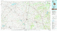
1985 Map of Mexia
USGS Topo · Published 1992About this map
Mexia State School and the ruins at Fort Parker anchor this mid-1980s landscape across Limestone, Navarro, and Freestone counties. The region is defined by its transition from prairie to river bottom, where the Navasota River and Richland Creek carve through the terrain. Evidence of the early 20th-century educational landscape remains through Westminster College at Tehuacana, a hilltop settlement overlooking the surrounding plains.
Find a feature on this map
192 named features on this map. Tap any name to fly to it.
Don’t see what you’re looking for? This feature index may not catch every label — zoom into the map to look around manually.
Map Details
Editions of this 1985 Mexia Map
2 editions found
Other maps of this area

1891 · Cleburne
USGS Topo · 1:125,000

1892 · Temple
USGS Topo · 1:125,000

1892 · Waco
USGS Topo · 1:125,000

1894 · Cleburne
USGS Topo · 1:125,000

1919 · Fairfield
USGS Topo · 1:62,500

1920 · Waco
USGS Topo · 1:125,000

1920 · Mexia
USGS Topo · 1:62,500

1920 · Mart
USGS Topo · 1:62,500

1931 · Elm Mott
USGS Topo · 1:62,500

1949 · Athens
USGS Topo · 1:62,500