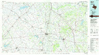
1985 Map of Mexia
USGS Topo · Published 1985About this map
Mexia State School and the historic grounds of Fort Parker State Park anchor this mid-1980s landscape across Limestone and Freestone counties. The area is defined by a dense network of water bodies, from the sprawling Navarro Mills Lake in the northwest to Fairfield Lake in the east, which supported the region's agricultural and industrial needs. Settlement patterns follow the established corridors of the St Louis Southwestern and Burlington Northern railroads, connecting towns like Mexia and Groesbeck.
Find a feature on this map
171 named features on this map. Tap any name to fly to it.
Don’t see what you’re looking for? This feature index may not catch every label — zoom into the map to look around manually.
Map Details
Editions of this 1985 Mexia Map
2 editions found
Other maps of this area

1891 · Cleburne
USGS Topo · 1:125,000

1892 · Temple
USGS Topo · 1:125,000

1892 · Waco
USGS Topo · 1:125,000

1894 · Cleburne
USGS Topo · 1:125,000

1919 · Fairfield
USGS Topo · 1:62,500

1920 · Waco
USGS Topo · 1:125,000

1920 · Mexia
USGS Topo · 1:62,500

1920 · Mart
USGS Topo · 1:62,500

1931 · Elm Mott
USGS Topo · 1:62,500

1949 · Athens
USGS Topo · 1:62,500