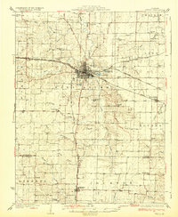
1932 Map of Mexico
USGS Topo · Published 1932About this map
Mexico serves as the central hub of this Missouri landscape, where the confluence of three major rail lines—the Chicago and Alton, the Wabash, and the Chicago Burlington and Quincy—dictated the town's early growth. The presence of the Mo Military Academy and the County Farm near the city limits reflects the institutional character of the regional seat. Beyond the urban center, the map reveals a dense network of rural life defined by one-room schoolhouses like Simms Sch and Jesse Sch, which anchored the agricultural townships of Linn and Prairie. The terrain is carved by the South Fork Salt River and its numerous tributaries, including Beaverdam Creek and Scattering Fork, illustrating the drainage patterns that shaped farm boundaries before the modernization of State Highway No 22.
Find a feature on this map
65 named features on this map. Tap any name to fly to it.
Don’t see what you’re looking for? This feature index may not catch every label — zoom into the map to look around manually.
Map Details
Editions of this 1932 Mexico Map
3 editions found
Other maps of this area

1886 · Jefferson City
USGS Topo · 1:125,000

1890 · Mexico
USGS Topo · 1:125,000

1890 · Moberly
USGS Topo · 1:125,000

1890 · Fulton
USGS Topo · 1:125,000

1894 · Jefferson City
USGS Topo · 1:125,000

1928 · Fulton
USGS Topo · 1:62,500

1931 · Fulton
USGS Topo · 1:62,500

1932 · Mexico
USGS Topo · 1:62,500

1940 · Montgomery City
USGS Topo · 1:62,500

1942 · Montgomery City
USGS Topo · 1:62,500