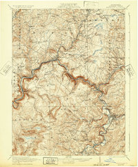
1921 Map of Meyersdale
USGS Topo · Published 1932About this map
The Allegheny Mountains of Somerset County define this 1920s landscape, anchored by the industrial hub of Meyersdale. The region’s extraction-based economy is evident through the heavy concentration of Beachley Mine, Wilson Creek Mines, and the Bare Rock Quarry. Transportation corridors follow the winding river valleys, with the Baltimore and Ohio and Western Maryland railroads tracing the Casselman River.
Find a feature on this map
124 named features on this map. Tap any name to fly to it.
Don’t see what you’re looking for? This feature index may not catch every label — zoom into the map to look around manually.
Map Details
Editions of this 1921 Meyersdale Map
3 editions found

Other maps of this area

1898 · Frostburg
USGS Topo · 1:62,500

1899 · Grantsville
USGS Topo · 1:62,500

1900 · Accident
USGS Topo · 1:62,500

1901 · Frostburg
USGS Topo · 1:62,500

1904 · Grantsville
USGS Topo · 1:62,500

1908 · Frostburg
USGS Topo · 1:62,500

1913 · Somerset
USGS Topo · 1:62,500

1914 · Windber
USGS Topo · 1:62,500

1915 · Somerset
USGS Topo · 1:62,500

1916 · Windber
USGS Topo · 1:62,500