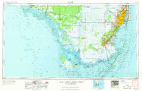
1956 Map of Miami
USGS Topo · Published 1969About this map
The vast wetlands of Everglades National Park and The Everglades dominate this mid-century portrait of South Florida. While the Atlantic coast shows the intensive development of Miami, Hialeah, and Hollywood, the western gulf side remains defined by the intricate labyrinth of the Ten Thousand Islands and remote outposts like Everglades City and Chokoloskee. The Tamiami Trail serves as the primary artery through this landscape, passing through isolated points such as Monroe Station and Forty Mile Bend. Along the southern tip at Cape Sable and Whitewater Bay, the map captures the transition from freshwater marshes to the saltwater environments of Florida Bay. Researchers will find significant infrastructure of the era, including the Homestead Air Force Base and the extensive network of drainage canals like the Miami Canal and Tamiami Canal that fundamentally reshaped the region's hydrology.
Find a feature on this map
219 named features on this map. Tap any name to fly to it.
Don’t see what you’re looking for? This feature index may not catch every label — zoom into the map to look around manually.
Map Details
Editions of this 1956 Miami Map
5 editions found


Other maps of this area

1947 · North Miami
USGS Topo · 1:24,000

1947 · Key Biscayne
USGS Topo · 1:24,000

1947 · Garden Cove
USGS Topo · 1:24,000

1947 · Rock Harbor
USGS Topo · 1:24,000

1947 · Blackwater Sound
USGS Topo · 1:24,000

1948 · Soldier Key
USGS Topo · 1:24,000

1949 · Blackwater Sound
USGS Topo · 1:24,000

1949 · Rock Harbor
USGS Topo · 1:24,000

1949 · Opalocka
USGS Topo · 1:24,000

1949 · Garden Cove
USGS Topo · 1:24,000