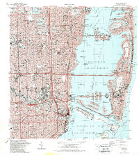
1988 Map of Miami
USGS Topo · Published 1988About this map
The Miami River cuts through the heart of the urban landscape in this late 1980s look at the city and its barrier islands. The map documents a metropolis shaped by its relationship with Biscayne Bay, where the Mac Arthur Causeway and Julia Tuttle Causeway connect the mainland to Miami Beach. The inland geography is defined by a dense grid of neighborhoods like Shenandoah and Allapattah, intersected by the Seaboard System railroad and major canals like the Biscayne Canal.
Find a feature on this map
92 named features on this map. Tap any name to fly to it.
Don’t see what you’re looking for? This feature index may not catch every label — zoom into the map to look around manually.
Map Details
Editions of this 1988 Miami Map
2 editions found
Other maps of this area

1947 · North Miami
USGS Topo · 1:24,000

1947 · Key Biscayne
USGS Topo · 1:24,000

1949 · Opalocka
USGS Topo · 1:24,000

1949 · Key Biscayne
USGS Topo · 1:24,000

1950 · Hialeah
USGS Topo · 1:24,000

1950 · Miami
USGS Topo · 1:24,000

1950 · North Miami
USGS Topo · 1:24,000

1950 · South Miami
USGS Topo · 1:24,000

1956 · South Miami
USGS Topo · 1:24,000

1956 · Miami
USGS Topo · 1:250,000