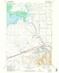
1971 Map of Michaud
USGS Topo · Published 1992About this map
The Fort Hall Bottoms and Michaud Flats define this stretch of the Idaho landscape, where the Portneuf River meets the eastern reaches of the American Falls Reservoir. This 1971 survey captures the area during a period of transition, showing the industrial development around Batiste and the Pocatello Municipal Airport alongside the rural boundaries of the Fort Hall Indian Reservation. The presence of the Indian Cem and Reider Cemetery provides valuable data for genealogists, while the numerous family-named roads like Reider Road, Wallin Road, and Havenor Road trace the local settlement patterns of the era. The map also records the specialized land use of the time, including a Fish Hatchery, a Drag Strip, and several Industrial Waste Ponds near the Bannock Co Power Co line.
Find a feature on this map
37 named features on this map. Tap any name to fly to it.
Don’t see what you’re looking for? This feature index may not catch every label — zoom into the map to look around manually.
Map Details
Editions of this 1971 Michaud Map
4 editions found
Other maps of this area

1934 · Michaud
USGS Topo · 1:62,500

1937 · Pocatello
USGS Topo · 1:48,000

1937 · Michaud
USGS Topo · 1:62,500

1940 · Blackfoot
USGS Topo · 1:62,500

1943 · Blackfoot
USGS Topo · 1:62,500

1944 · Pocatello
USGS Topo · 1:62,500

1954 · Pocatello
USGS Topo · 1:250,000

1955 · Pingree
USGS Topo · 1:24,000

1955 · Springfield
USGS Topo · 1:24,000

1955 · Idaho Falls
USGS Topo · 1:250,000