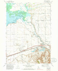
1971 Map of Michaud
USGS Topo · Published 1986About this map
The Fort Hall Bottoms and the broad expanse of Michaud Flats define this 1971 landscape along the Portneuf River. The convergence of the river with the American Falls Reservoir creates a complex wetland environment, marked by numerous springs and the winding channels of Clear Creek. The area’s spiritual and cultural history is visible in the Indian Cem and a small Church located north of the flats.
Find a feature on this map
53 named features on this map. Tap any name to fly to it.
Don’t see what you’re looking for? This feature index may not catch every label — zoom into the map to look around manually.
Map Details
Editions of this 1971 Michaud Map
4 editions found
Other maps of this area

1934 · Michaud
USGS Topo · 1:62,500

1937 · Pocatello
USGS Topo · 1:48,000

1937 · Michaud
USGS Topo · 1:62,500

1940 · Blackfoot
USGS Topo · 1:62,500

1943 · Blackfoot
USGS Topo · 1:62,500

1944 · Pocatello
USGS Topo · 1:62,500

1954 · Pocatello
USGS Topo · 1:250,000

1955 · Pingree
USGS Topo · 1:24,000

1955 · Springfield
USGS Topo · 1:24,000

1955 · Idaho Falls
USGS Topo · 1:250,000