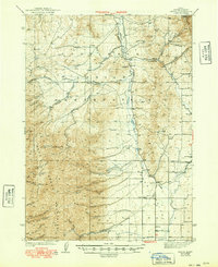
1944 Map of Arbon
USGS Topo · Published 1949About this map
The Fort Hall Indian Reservation encompasses a large portion of this Idaho landscape, dominated by the Bannock Range and the Deep Creek Mountains. The geography is defined by a series of north-south running valleys and high peaks, including Bannock Pk and White Quartz Mtn. In the lower elevations, the small community of Arbon and the settlement at Pauline serve as centers for this rural district, which was surveyed shortly before the outbreak of World War II. The map records several family-named ranching operations, such as Rudeen Ranch and Jensen Ranch, which are situated along the drainages of Bannock Creek and Crystal Creek. An early twentieth-century aviation corridor is evident through the presence of an Airway Beacon and a dedicated Landing Field, illustrating how modern infrastructure was integrated into this traditional ranching country. Local education is noted at the Armstrong Sch and Arbon Sch, marking the scattered social hubs of Power County.
Find a feature on this map
50 named features on this map. Tap any name to fly to it.
Don’t see what you’re looking for? This feature index may not catch every label — zoom into the map to look around manually.
Map Details
Editions of this 1944 Arbon Map
2 editions found
Other maps of this area

1934 · American Falls
USGS Topo · 1:62,500

1934 · Michaud
USGS Topo · 1:62,500

1934 · Rockland
USGS Topo · 1:62,500

1936 · American Falls
USGS Topo · 1:62,500

1937 · Rockland
USGS Topo · 1:62,500

1937 · Pocatello
USGS Topo · 1:48,000

1937 · Michaud
USGS Topo · 1:62,500

1938 · Pauline
USGS Topo · 1:48,000

1944 · Pocatello
USGS Topo · 1:62,500

1944 · Arbon
USGS Topo · 1:62,500