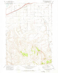
1971 Map of Wheatgrass Bench
USGS Topo · Published 1974About this map
The Fort Hall Indian Reservation Boundary defines the northwestern portion of this 1971 Idaho survey, where the sagebrush landscape meets the eastern edge of the American Falls Reservoir. The terrain is characterized by broad plateaus like Wheatgrass Bench and the Compressor Station Bench, segmented by a network of agricultural and industrial infrastructure. A significant Sun Dance Ground is located near the reservation line, indicating the deep cultural history of the area.
Find a feature on this map
30 named features on this map. Tap any name to fly to it.
Don’t see what you’re looking for? This feature index may not catch every label — zoom into the map to look around manually.
Map Details
Editions of this 1971 Wheatgrass Bench Map
This is the sole edition of this map. No revisions or reprints were ever made.
Other maps of this area

1934 · American Falls
USGS Topo · 1:62,500

1934 · Michaud
USGS Topo · 1:62,500

1934 · Rockland
USGS Topo · 1:62,500

1936 · American Falls
USGS Topo · 1:62,500

1937 · Rockland
USGS Topo · 1:62,500

1937 · Michaud
USGS Topo · 1:62,500

1938 · Pauline
USGS Topo · 1:48,000

1944 · Arbon
USGS Topo · 1:62,500

1954 · Pocatello
USGS Topo · 1:250,000

1958 · Pocatello
USGS Topo · 1:250,000