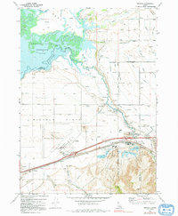
1971 Map of Michaud
USGS Topo · Published 1991About this map
The Fort Hall Bottoms and the sprawling Michaud Flats dominate this topographic landscape in the early 1970s, illustrating the complex intersection of natural water systems and industrial development. The American Falls Reservoir and the winding Portneuf River dictate the local geography, providing the necessary resources for infrastructure like the Bannock Power Co and various irrigation features including the Tyhee Wasteway and several unnamed aqueducts.
Find a feature on this map
52 named features on this map. Tap any name to fly to it.
Don’t see what you’re looking for? This feature index may not catch every label — zoom into the map to look around manually.
Map Details
Editions of this 1971 Michaud Map
4 editions found
Other maps of this area

1934 · Michaud
USGS Topo · 1:62,500

1937 · Pocatello
USGS Topo · 1:48,000

1937 · Michaud
USGS Topo · 1:62,500

1940 · Blackfoot
USGS Topo · 1:62,500

1943 · Blackfoot
USGS Topo · 1:62,500

1944 · Pocatello
USGS Topo · 1:62,500

1954 · Pocatello
USGS Topo · 1:250,000

1955 · Pingree
USGS Topo · 1:24,000

1955 · Springfield
USGS Topo · 1:24,000

1955 · Idaho Falls
USGS Topo · 1:250,000