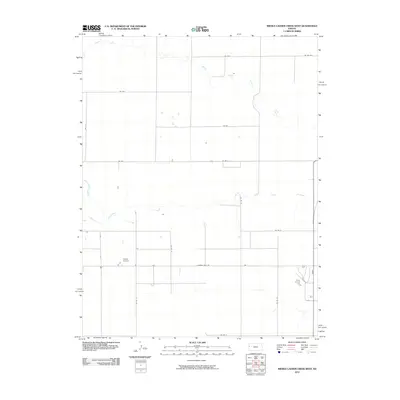
2010 Map of Middle Ladder Creek West
USGS Topo · Published 2010About this map
South Ladder Creek and Middle Ladder Creek define the geography of this Western Kansas landscape, carving distinct drainage patterns across the high plains of Greeley County. This corner of Tribune Township is characterized by a precise grid of rural thoroughfares, including named routes such as Thirteen Mile Rd and Co Rd F, which reflect the late twentieth-century transportation network in this agricultural region. The inclusion of Walter Airport provides a specific point of interest for local history, marking the infrastructure supporting the area's light aviation and farming operations. The terrain is marked by ephemeral water bodies and the subtle elevation changes of the South Fork drainage, illustrating the hydraulic character of the High Plains before the widespread modern shifts in groundwater and land use.
Find a feature on this map
18 named features on this map. Tap any name to fly to it.
Don’t see what you’re looking for? This feature index may not catch every label — zoom into the map to look around manually.
Map Details
Editions of this 2010 Middle Ladder Creek West Map
This is the sole edition of this map. No revisions or reprints were ever made.
Other maps of this area

1955 · Scott City
USGS Topo · 1:250,000

1958 · Scott City
USGS Topo · 1:250,000

1959 · Weskan
USGS Topo · 1:62,500

1959 · Wallace
USGS Topo · 1:62,500

1968 · Sharon Springs 3 NE
USGS Topo · 1:24,000

1968 · Sharon Springs 4 NW
USGS Topo · 1:24,000

1968 · Sharon Springs 3 NW
USGS Topo · 1:24,000

1970 · Sharon Springs 3 SE
USGS Topo · 1:24,000

1970 · Sharon Springs 4 SW
USGS Topo · 1:24,000
1970 · Sharon Springs 3 SW
USGS Topo · 1:24,000
Featured Places
- Tribune Township, KS
- Weskan Township, KS
- Sharon Springs Township, KS
- Wallace County, KS
- Greeley County, KS