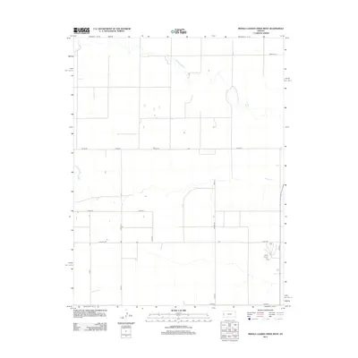
2012 Map of Middle Ladder Creek West
USGS Topo · Published 2012About this map
Middle Ladder Cr meanders through the high plains of Greeley County, defining the drainage patterns of this agricultural landscape in the early 21st century. The map reveals a strictly regulated grid of section lines and transport corridors, where Horace Rd and 13 Mile Rd serve as primary arteries for the surrounding township. This network of rural routes, including Co Road A and Co Line Rd, reflects the enduring Homestead-era land division system that continues to dictate the placement of farmsteads and property boundaries. The sparse distribution of man-made structures highlights the expansive nature of modern dryland farming and ranching operations typical of the western Kansas borderlands. Local history researchers can trace the connectivity between remote tracts and the larger regional hubs through the naming of local landmarks such as Co Road F and 11 Mile Rd.
Find a feature on this map
13 named features on this map. Tap any name to fly to it.
Don’t see what you’re looking for? This feature index may not catch every label — zoom into the map to look around manually.
Map Details
Editions of this 2012 Middle Ladder Creek West Map
This is the sole edition of this map. No revisions or reprints were ever made.
Other maps of this area

1955 · Scott City
USGS Topo · 1:250,000

1958 · Scott City
USGS Topo · 1:250,000

1959 · Weskan
USGS Topo · 1:62,500

1959 · Wallace
USGS Topo · 1:62,500

1968 · Sharon Springs 3 NE
USGS Topo · 1:24,000

1968 · Sharon Springs 4 NW
USGS Topo · 1:24,000

1968 · Sharon Springs 3 NW
USGS Topo · 1:24,000

1970 · Sharon Springs 3 SE
USGS Topo · 1:24,000

1970 · Sharon Springs 4 SW
USGS Topo · 1:24,000
1970 · Sharon Springs 3 SW
USGS Topo · 1:24,000
Featured Places
- Tribune Township, KS
- Weskan Township, KS
- Sharon Springs Township, KS
- Wallace County, KS
- Greeley County, KS