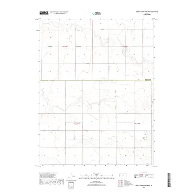
2018 Map of Middle Ladder Creek West
USGS Topo · Published 2018About this map
The high plains borderland between Wallace and Greeley counties is defined by a sparse, geometric network of rural routes and sectional lines. This portion of Western Kansas is characterized by the expansive drainage of Ladder Creek, where the terrain is navigated via descriptively named tracks like Dusty Rd, Bumpy Rd, and the uniquely spelled Crosswind Raod. The map illustrates a landscape of large-scale agricultural land management, where local travel relies on the intersection of established county roads such as Horace Rd and Thirteen Mile Rd. This late 2010s survey captures the contemporary layout of the High Plains, where human presence is marked by isolated structures and a rigid grid system that persists through several townships including t16s r41w and t15s r40w.
Find a feature on this map
27 named features on this map. Tap any name to fly to it.
Don’t see what you’re looking for? This feature index may not catch every label — zoom into the map to look around manually.
Map Details
Editions of this 2018 Middle Ladder Creek West Map
This is the sole edition of this map. No revisions or reprints were ever made.
Other maps of this area

1955 · Scott City
USGS Topo · 1:250,000

1958 · Scott City
USGS Topo · 1:250,000

1959 · Weskan
USGS Topo · 1:62,500

1959 · Wallace
USGS Topo · 1:62,500

1968 · Sharon Springs 3 NE
USGS Topo · 1:24,000

1968 · Sharon Springs 4 NW
USGS Topo · 1:24,000

1968 · Sharon Springs 3 NW
USGS Topo · 1:24,000

1970 · Sharon Springs 3 SE
USGS Topo · 1:24,000

1970 · Sharon Springs 4 SW
USGS Topo · 1:24,000
1970 · Sharon Springs 3 SW
USGS Topo · 1:24,000
Featured Places
- Tribune Township, KS
- Weskan Township, KS
- Sharon Springs Township, KS
- Wallace County, KS
- Greeley County, KS