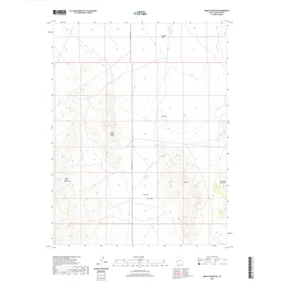
2020 Map of Middle Mountain
USGS Topo · Published 2020About this map
Pine Pass Reservoir sits at the heart of this high-desert landscape in Millard County, marking a vital water point between several prominent geological formations. The terrain is defined by the elevation changes of the Tunnel Spring Mountains to the west and the northern reaches of the Wah Wah Mountains to the east. This 2020 survey illustrates the remote basin-and-range topography typical of western Utah, where isolated peaks like Mid Mtn and Cat Knoll rise above the alluvial fans. The presence of Crystal Peak Rd provides the primary transit through Pine Pass, connecting the Ferguson Desert to the north with Pine Valley in the south. The map details a largely uninhabited expanse where land management and natural drainage patterns, such as those from the Little Rough Range, dictate the character of the region.
Find a feature on this map
11 named features on this map. Tap any name to fly to it.
Don’t see what you’re looking for? This feature index may not catch every label — zoom into the map to look around manually.
Map Details
Editions of this 2020 Middle Mountain Map
This is the sole edition of this map. No revisions or reprints were ever made.
Other maps of this area

1953 · Richfield
USGS Topo · 1:250,000

1958 · Richfield
USGS Topo · 1:250,000

1960 · Burbank Hills
USGS Topo · 1:62,500

1960 · Wah Wah Summit
USGS Topo · 1:62,500

1960 · Crystal Peak
USGS Topo · 1:62,500

1971 · Tunnel Spring
USGS Topo · 1:24,000

1980 · Wah Wah Mts. North
USGS Topo · 1:100,000
1989 · Pine Valley Hardpan North
USGS Topo · 1:24,000
1989 · Grassy Cove
USGS Topo · 1:24,000
1991 · King Top
USGS Topo · 1:24,000