
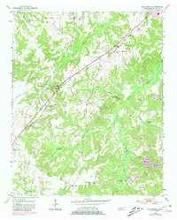
1950 Map of Middleburg
USGS Topo · Published 1975About this map
The Illinois Central railroad cuts a diagonal path through this 1950s landscape, serving as the primary industrial corridor for small settlements like Middleburg and Hickory Valley. The surrounding Hardeman County countryside is defined by an intricate network of creeks, including Pleasant Run, Snow Creek, and Spring Creek, which wind through the terrain. These waterways historically influenced the placement of rural institutions such as the Sugar Hill Sch and Van Buren Sch.
Find a feature on this map
24 named features on this map. Tap any name to fly to it.
Don’t see what you’re looking for? This feature index may not catch every label — zoom into the map to look around manually.
Map Details
Editions of this 1950 Middleburg Map
2 editions found
Other maps of this area

1950 · Hebron
USGS Topo · 1:24,000

1950 · Middleton
USGS Topo · 1:24,000

1950 · Grand Junction
USGS Topo · 1:24,000

1951 · Middleton
USGS Topo · 1:24,000

1951 · Middleburg
USGS Topo · 1:24,000

1951 · Hebron
USGS Topo · 1:24,000

1951 · Hickory Valley
USGS Topo · 1:24,000

1951 · Grand Junction
USGS Topo · 1:24,000

1952 · Saulsbury
USGS Topo · 1:24,000

1956 · Blytheville
USGS Topo · 1:250,000