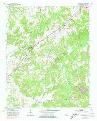
1950 Map of Middleburg
USGS Topo · Published 1981About this map
Middleburg and Hickory Valley anchor the western corridor of this Hardeman County survey, where the Illinois Central Gulf railroad cuts a straight line through the undulating terrain. Originally based on 1947 aerial photography and checked in 1950, the data reflects a mid-century landscape of small rural settlements, family cemeteries, and local landmarks. The map shows a transition in land use toward the 1980s, including the development of Grand Valley Lake and the Bolivar-Hardeman Co Airport near the north-central boundary.
Find a feature on this map
28 named features on this map. Tap any name to fly to it.
Don’t see what you’re looking for? This feature index may not catch every label — zoom into the map to look around manually.
Map Details
Editions of this 1950 Middleburg Map
2 editions found
Other maps of this area

1950 · Hebron
USGS Topo · 1:24,000

1950 · Middleburg
USGS Topo · 1:24,000

1950 · Middleton
USGS Topo · 1:24,000

1950 · Grand Junction
USGS Topo · 1:24,000

1951 · Middleton
USGS Topo · 1:24,000

1951 · Middleburg
USGS Topo · 1:24,000

1951 · Hebron
USGS Topo · 1:24,000

1951 · Hickory Valley
USGS Topo · 1:24,000

1951 · Grand Junction
USGS Topo · 1:24,000

1952 · Saulsbury
USGS Topo · 1:24,000