
1984 Map of Midland
USGS Topo · Published 1985About this map
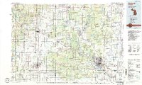
The Tittabawassee River and its major tributaries, the Chippewa River and Tobacco River, define the hydrological character of this mid-Michigan landscape. In the mid-1980s, the industrial hub of Midland and the regional center of Mount Pleasant anchor the eastern and western portions of the map, respectively. Significant portions of the land are dedicated to the Au Sable State Forest, while the presence of an extensive Oil Field and numerous Gravel Pits reflects the area's resource-based economy. The transportation network is dominated by the Chesapeake and Ohio railroad line, which cuts diagonally through the terrain, connecting smaller settlements like Coleman and Loomis. For those researching local heritage, the map preserves the locations of smaller communities such as Edenville, Rosebush, and Beal City, alongside spiritual landmarks like St Joseph Ch.
Find a feature on this map
150 named features on this map. Tap any name to fly to it.
Don’t see what you’re looking for? This feature index may not catch every label — zoom into the map to look around manually.
Map Details
Editions of this 1984 Midland Map
2 editions found
Historical Maps of Midland Through Time
5 maps found


