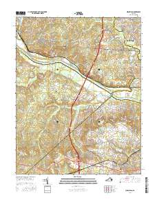
2016 Map of Midlothian
USGS Topo · Published 2016About this map
The James River snakes through the heart of this Virginia landscape, marking the historical boundaries between Goochland, Henrico, Powhatan, and Chesterfield counties. Near the river's bend, the community of Manakin and the residential growth of Manakin Farms sit north of Sabot Island, while the southern bank transition toward the suburban patterns of Midlothian. This survey documents a region defined by its crossing points and long-standing landmarks, including the Boscobel Ferry Rd and numerous historic burial sites such as Saint Marys Cem and Mount Pisgah Cem. Local hydrography is characterized by several tributaries like Bernards Creek and Tuckahoe Cr, alongside developed water bodies like Lake Patrick Henry and Salisbury Lake. These features, along with the Southern railroad line, illustrate the evolving infrastructure of a region balancing its rural riverfront heritage with modern expansion.
Find a feature on this map
212 named features on this map. Tap any name to fly to it.
Don’t see what you’re looking for? This feature index may not catch every label — zoom into the map to look around manually.
Map Details
Editions of this 2016 Midlothian Map
This is the sole edition of this map. No revisions or reprints were ever made.
Other maps of this area

1890 · Goochland
USGS Topo · 1:125,000

1892 · Goochland
USGS Topo · 1:125,000

1897 · Amelia
USGS Topo · 1:125,000

1936 · Richmond West
USGS Topo · 1:24,000

1936 · Glen Allen
USGS Topo · 1:24,000

1941 · Glen Allen
USGS Topo · 1:31,680

1942 · Westhampton
USGS Topo · 1:31,680

1943 · Fine Creek Mills
USGS Topo · 1:31,680

1943 · Chesterfield
USGS Topo · 1:31,680

1943 · Perkinsville
USGS Topo · 1:31,680