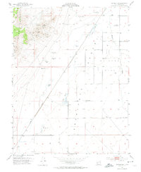
1953 Map of Milford Flat
USGS Topo · Published 1974About this map
Mining operations in the Star Range define the western portion of this mid-century survey, with several named sites including the Maud-S Mine, Vicksburg Mine, and Gold Crown Mine clustered among the peaks. These industrial landmarks overlook the Escalante Desert and the wide, flat expanse of Milford Flat to the east. Transportation and water management are central to the landscape, marked by the prominent corridor of the Union Pacific railroad and the Trans River Canal near the Beaver River. Small settlements and rail points like Upton, Cook Corner, and Laho provide geographical anchors for local family history. The presence of numerous named water sources, such as Tadpole Springs and Hay Springs, alongside several dry wells like Hearn Well, illustrates the critical importance of water rights and irrigation in this arid Utah environment.
Find a feature on this map
29 named features on this map. Tap any name to fly to it.
Don’t see what you’re looking for? This feature index may not catch every label — zoom into the map to look around manually.
Map Details
Editions of this 1953 Milford Flat Map
2 editions found
Other maps of this area

1885 · Beaver
USGS Topo · 1:250,000

1953 · Ninemile Knoll
USGS Topo · 1:24,000

1953 · Milford Flat
USGS Topo · 1:24,000

1953 · Minersville
USGS Topo · 1:24,000

1953 · Cave Canyon
USGS Topo · 1:24,000

1953 · Richfield
USGS Topo · 1:250,000

1958 · Richfield
USGS Topo · 1:250,000

1958 · Minersville
USGS Topo · 1:62,500

1958 · Thermo
USGS Topo · 1:62,500

1958 · Milford
USGS Topo · 1:62,500