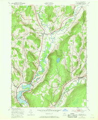
1943 Map of Milford
USGS Topo · Published 1968About this map
The Susquehanna River defines the central valley of this Otsego County landscape, where the Delaware and Hudson railroad tracks parallel the water through Milford and south toward Portlandville. This mid-century survey captures a rural New York economy organized around these transport corridors and the smaller creek valleys of the Cherry Valley Creek and Schenevus Creek. Higher elevations like Crumhorn Mountain and Burying Ground Hill remain largely undeveloped, while the valley floors are dotted with local landmarks for genealogists, including School No 8 and several family-named burial sites like Waters Cem. The lower reaches of the map show the impact of river management on the terrain, notably at Goodyear Lake near Cliffside, illustrating the 1940s balance between agricultural land and growing water infrastructure.
Find a feature on this map
40 named features on this map. Tap any name to fly to it.
Don’t see what you’re looking for? This feature index may not catch every label — zoom into the map to look around manually.
Map Details
Editions of this 1943 Milford Map
4 editions found
Other maps of this area

1907 · Cooperstown
USGS Topo · 1:62,500

1909 · Cooperstown
USGS Topo · 1:62,500

1909 · Delhi
USGS Topo · 1:62,500

1910 · Hartwick
USGS Topo · 1:62,500

1911 · Delhi
USGS Topo · 1:62,500

1912 · Hartwick
USGS Topo · 1:62,500

1915 · Oneonta
USGS Topo · 1:62,500

1918 · Oneonta
USGS Topo · 1:62,500

1943 · Mt Vision
USGS Topo · 1:24,000

1943 · Milford
USGS Topo · 1:24,000