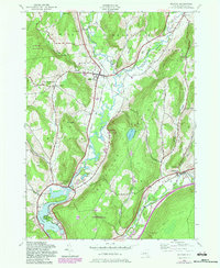
1943 Map of Milford
USGS Topo · Published 1983About this map
The Susquehanna River valley serves as the central artery for this Otsego County landscape, where the Delaware and Hudson railroad tracks trace the river's winding course. This mid-century view captures a network of small settlements like Milford, Portlandville, and Westville as they appeared before modern development altered the rural character of the hills. The terrain is marked by significant elevations such as Crumhorn Mountain and the prominent Burying Ground Hill near Edson Corners.
Find a feature on this map
49 named features on this map. Tap any name to fly to it.
Don’t see what you’re looking for? This feature index may not catch every label — zoom into the map to look around manually.
Map Details
Editions of this 1943 Milford Map
4 editions found
Other maps of this area

1907 · Cooperstown
USGS Topo · 1:62,500

1909 · Cooperstown
USGS Topo · 1:62,500

1909 · Delhi
USGS Topo · 1:62,500

1910 · Hartwick
USGS Topo · 1:62,500

1911 · Delhi
USGS Topo · 1:62,500

1912 · Hartwick
USGS Topo · 1:62,500

1915 · Oneonta
USGS Topo · 1:62,500

1918 · Oneonta
USGS Topo · 1:62,500

1943 · Mt Vision
USGS Topo · 1:24,000

1943 · Milford
USGS Topo · 1:24,000