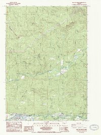
1985 Map of Mill City North
USGS Topo · Published 1985About this map
The North Santiam River carves a deep path through this mid-1980s landscape, serving as the county line between Marion Co and Linn Co. The settlement of Mill City anchors the southwestern corner of the map, while the Elkhorn Valley to the east represents a corridor of recreation and timber management. Much of the terrain is defined by the Santiam State Forest, where numerous borrow pits and a Quarry indicate the ongoing maintenance of mountain access roads like the Steel Line.
Find a feature on this map
37 named features on this map. Tap any name to fly to it.
Don’t see what you’re looking for? This feature index may not catch every label — zoom into the map to look around manually.
Map Details
Editions of this 1985 Mill City North Map
2 editions found
Other maps of this area

1929 · Mill City
USGS Topo · 1:125,000

1951 · Lyons
USGS Topo · 1:62,500

1951 · Snow Peak
USGS Topo · 1:62,500

1953 · Salem
USGS Topo · 1:250,000

1954 · Salem
USGS Topo · 1:250,000

1955 · Mill City
USGS Topo · 1:62,500

1956 · Quartzville
USGS Topo · 1:62,500

1960 · Salem
USGS Topo · 1:250,000

1962 · Salem
USGS Topo · 1:250,000

1963 · Salem
USGS Topo · 1:250,000