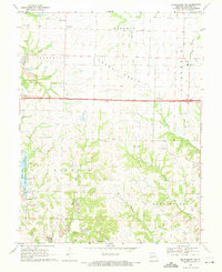
1969 Map of Millersburg NE
USGS Topo · Published 1971About this map
Little Dixie State Wildlife Management Area anchors the southwestern quadrant of this Callaway County survey, featuring the waters of Little Dixie Lake and its associated Fish Hatchery. The landscape transitions from the open stretches of Grand Prairie in the north to the dissected creek valleys of Bourbon and West Fulton townships. Civil life during this era is marked by scattered rural congregations such as Rising Sun Ch, Prairie Chapel, and New Richland Ch, while the Mt Olivet Cem and the Callaway R 1 Sch serve the local families in Hereford and Eastville. Industrial activity is evident in the several Strip Mines and Strip Mine operations concentrated near the western boundary. A major 2 Lane highway bisects the map horizontally, providing a primary transit corridor between the small hamlets and the larger drainage systems of Auxvasse Creek and Middle River.
Find a feature on this map
27 named features on this map. Tap any name to fly to it.
Don’t see what you’re looking for? This feature index may not catch every label — zoom into the map to look around manually.
Map Details
Editions of this 1969 Millersburg NE Map
2 editions found
Other maps of this area

1886 · Jefferson City
USGS Topo · 1:125,000

1890 · Mexico
USGS Topo · 1:125,000

1890 · Moberly
USGS Topo · 1:125,000

1890 · Fulton
USGS Topo · 1:125,000

1894 · Jefferson City
USGS Topo · 1:125,000

1928 · Fulton
USGS Topo · 1:62,500

1931 · Fulton
USGS Topo · 1:62,500

1932 · Mexico
USGS Topo · 1:62,500

1944 · Millersburg
USGS Topo · 1:62,500

1945 · Centralia
USGS Topo · 1:62,500