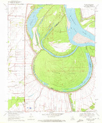
1970 Map of Millikin
USGS Topo · Published 1972About this map
The Mississippi River dominates this landscape, where the dynamic shifts of the riverbed have created massive landforms like Pittman Island and Sarah Island. The 1970 state of the shoreline is captured through significant hydraulic features including Bunchs Cutoff and Sarah Cutoff, which separate active river channels from remnants like Old River and Gassoway Lake. On the Louisiana side, the Missouri Pacific railroad corridor serves as the primary axis for local settlements, connecting the communities of Millikin and Shelburn. This area is particularly rich for genealogical research, documenting numerous rural spiritual and burial sites such as Jerusalem Ch, Mt Pleasant Ch, and Panola Cem. The landscape is a complex network of agriculture and water management, evidenced by the many drainage bayous and a Landing Strip situated along the river's edge.
Find a feature on this map
32 named features on this map. Tap any name to fly to it.
Don’t see what you’re looking for? This feature index may not catch every label — zoom into the map to look around manually.
Map Details
Editions of this 1970 Millikin Map
2 editions found
Other maps of this area

1909 · Baxter Bayou
USGS Topo · 1:24,000

1909 · Lake Providence
USGS Topo · 1:24,000

1909 · Wilsons Point
USGS Topo · 1:24,000

1909 · Millikin
USGS Topo · 1:24,000

1909 · Ashton Bridge
USGS Topo · 1:24,000

1911 · Lake Providence
USGS Topo · 1:31,680

1911 · Baxter Bayou
USGS Topo · 1:24,000

1912 · Ashton Bridge
USGS Topo · 1:31,680

1913 · Wilson Point
USGS Topo · 1:31,680

1914 · Baxter Bayou
USGS Topo · 1:31,680