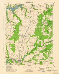
1944 Map of Millington
USGS Topo · Published 1944About this map
The intersection of the Pennsylvania (Chestertown Branch) and the Pennsylvania (Centerville Branch) at Massey serves as the structural heart of this 1944 survey. This rural landscape along the Maryland-Delaware border is defined by a series of small agricultural and railway settlements, including Golts, Sassafras, and Crumpton. The northern boundary is marked by the Sassafras River, while the Chester River winds along the southern edge, illustrating the importance of tidal waterways to the region's historical geography.
Find a feature on this map
40 named features on this map. Tap any name to fly to it.
Don’t see what you’re looking for? This feature index may not catch every label — zoom into the map to look around manually.
Map Details
Editions of this 1944 Millington Map
This is the sole edition of this map. No revisions or reprints were ever made.
Other maps of this area

1899 · Dover
USGS Topo · 1:125,000

1900 · Cecilton
USGS Topo · 1:62,500

1905 · Barclay
USGS Topo · 1:62,500

1906 · Dover
USGS Topo · 1:125,000

1920 · Dover
USGS Topo · 1:125,000

1926 · Wyoming
USGS Topo · 1:48,000

1930 · Wyoming
USGS Topo · 1:62,500

1931 · Wyoming
USGS Topo · 1:62,500

1931 · Smyrna
USGS Topo · 1:62,500
1944 · Earleville
USGS Topo · 1:31,680