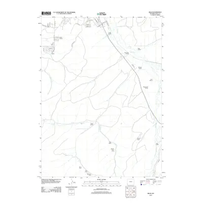
2012 Map of Millis
USGS Topo · Published 2012About this map
Bear River meanders through this portion of Uinta County, shaping a landscape defined by an intricate network of drainage draws and named hollows. Residential development is clustered in the northwest near Yellow Creek Rd, where a dense grid of streets including Tomahawk Dr and Arrowhead Dr marks the suburban expansion of the area. The map illustrates a clear division between these emerging neighborhoods and the surrounding rural terrain, where the names of early settlers or local landmarks are preserved in features like Knight Hollow, Glasscock Hollow, and Bernard Hollow. To the south, the terrain becomes increasingly complex as the Bear River creates a wide valley flanked by Sandy Ridge and punctuated by seasonal drainages such as Coyote Cr and Bog Draw, reflecting the importance of water management in this high-desert environment.
Find a feature on this map
41 named features on this map. Tap any name to fly to it.
Don’t see what you’re looking for? This feature index may not catch every label — zoom into the map to look around manually.
Map Details
Editions of this 2012 Millis Map
This is the sole edition of this map. No revisions or reprints were ever made.
Other maps of this area

1954 · Ogden
USGS Topo · 1:250,000

1958 · Ogden
USGS Topo · 1:250,000

1960 · Ogden
USGS Topo · 1:250,000

1965 · Evanston
USGS Topo · 1:24,000

1965 · Myers Reservoir
USGS Topo · 1:24,000

1965 · Sulphur Creek Reservoir
USGS Topo · 1:24,000

1965 · Guild Hollow
USGS Topo · 1:24,000
1965 · Pine Knoll
USGS Topo · 1:24,000

1965 · Millis
USGS Topo · 1:24,000

1968 · Wahsatch
USGS Topo · 1:24,000