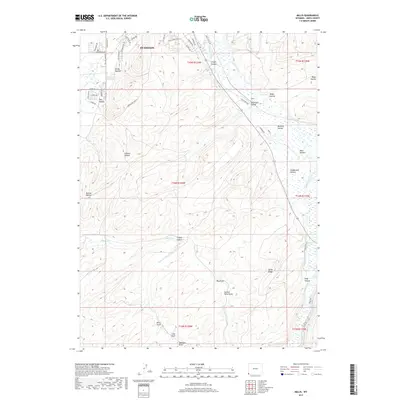
2017 Map of Millis
USGS Topo · Published 2017About this map
The southeastern outskirts of Evanston anchor this modern survey of Uinta County, where residential development meets a landscape of named draws and hollows. The Bear River meanders through the eastern portion of the quadrangle, accompanied by the City Ditch and a network of local roads such as Castlehale Way and Spaulding Ln. The terrain is deeply inscribed with historical family and descriptive names, including Glasscock Hollow, Bernard Hollow, and Stagecoach Hollow, suggesting the early routes and homesteading patterns of this Wyoming region.
Find a feature on this map
56 named features on this map. Tap any name to fly to it.
Don’t see what you’re looking for? This feature index may not catch every label — zoom into the map to look around manually.
Map Details
Editions of this 2017 Millis Map
This is the sole edition of this map. No revisions or reprints were ever made.
Other maps of this area

1954 · Ogden
USGS Topo · 1:250,000

1958 · Ogden
USGS Topo · 1:250,000

1960 · Ogden
USGS Topo · 1:250,000

1965 · Evanston
USGS Topo · 1:24,000

1965 · Myers Reservoir
USGS Topo · 1:24,000

1965 · Sulphur Creek Reservoir
USGS Topo · 1:24,000

1965 · Guild Hollow
USGS Topo · 1:24,000
1965 · Pine Knoll
USGS Topo · 1:24,000

1965 · Millis
USGS Topo · 1:24,000

1968 · Wahsatch
USGS Topo · 1:24,000