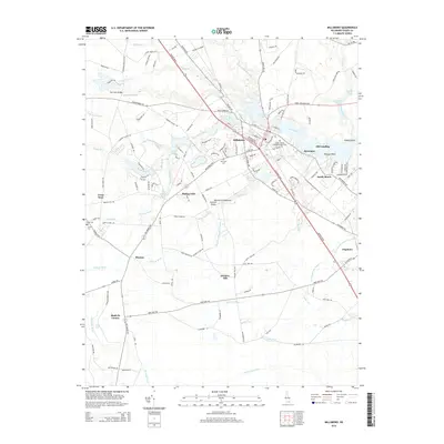
2014 Map of Millsboro
USGS Topo · Published 2014About this map
Millsboro and Dagsboro anchor this 2014 study of the Delmarva Peninsula Eastern Shore, where the headwaters of the Indian River meet an intricate network of drainage systems. The landscape is defined by its hydrologic history, featuring numerous impoundments like Millsboro Pond and Betts Pond, alongside man-made improvements such as the Long Drain Ditch and Houston-Thorogood Ditch. These waterways reflect the agricultural and industrial adaptation of the Delaware coastal plain. Local history is well-preserved through small crossroads communities and family landmarks, including Shaft Ox Corner and Phillips Hill. Genealogists may find value in the documentation of the Old Field Cem and the American Men Cem near the town centers. To the south, the terrain transitions toward the upper reaches of the Pocomoke River, illustrating the low-lying nature of the region's interior drainage divide.
Find a feature on this map
149 named features on this map. Tap any name to fly to it.
Don’t see what you’re looking for? This feature index may not catch every label — zoom into the map to look around manually.
Map Details
Editions of this 2014 Millsboro Map
This is the sole edition of this map. No revisions or reprints were ever made.
Other maps of this area

1901 · Ocean City
USGS Topo · 1:62,500

1902 · Pittsville
USGS Topo · 1:62,500

1917 · Millsboro
USGS Topo · 1:62,500

1918 · Rehoboth
USGS Topo · 1:62,500

1938 · Millsboro
USGS Topo · 1:62,500

1938 · Rehoboth
USGS Topo · 1:62,500

1942 · Ocean City
USGS Topo · 1:62,500

1942 · Whaleysville
USGS Topo · 1:24,000

1942 · Pittsville
USGS Topo · 1:24,000

1943 · Selbyville
USGS Topo · 1:31,680