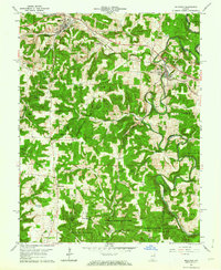
1962 Map of Milltown
USGS Topo · Published 1973About this map
Milltown and Marengo serve as the primary population centers in this 1960s study of the Blue River valley. The Southern railway line provides a critical transportation corridor through the north, passing by the distinctively named Hogtown and several industrial Quarry sites and Tailings near Marengo. This landscape is defined by its complex topography, where prominent peaks like Pilot Knob and Buzzard Roost Hill rise above the deep incisions of Whiskey Run and Devils Hollow.
Find a feature on this map
45 named features on this map. Tap any name to fly to it.
Don’t see what you’re looking for? This feature index may not catch every label — zoom into the map to look around manually.
Map Details
Editions of this 1962 Milltown Map
3 editions found
Other maps of this area

1931 · Corydon
USGS Topo · 1:62,500

1944 · Corydon West
USGS Topo · 1:24,000

1946 · Leavenworth
USGS Topo · 1:24,000

1946 · Depauw
USGS Topo · 1:24,000

1947 · Leavenworth
USGS Topo · 1:24,000

1947 · Corydon West
USGS Topo · 1:24,000

1947 · Hardinsburg
USGS Topo · 1:24,000

1948 · Milltown
USGS Topo · 1:24,000

1949 · Hardinsburg
USGS Topo · 1:24,000

1950 · Beechwood
USGS Topo · 1:24,000