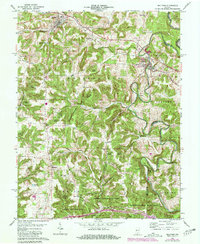
1962 Map of Milltown
USGS Topo · Published 1981About this map
The Blue River winds through the border of Crawford and Harrison Counties, carving a path through the extensive tracts of the Harrison-Crawford State Forest. This landscape is defined by its deep hollows and high ridges, including the distinctive Buzzard Roost Hill and Benz Hill. The settlement pattern follows the contours of the land and the path of the Southern railroad, which serves the primary communities of Marengo and Milltown. Local industry is evident at the Quarry near Marengo, while rural life centers around numerous upland congregations such as White Gem Ch and Pilot Knob Ch. The map reveals a network of country roads, including Leavenworth Road and Old Mill Road, which connect isolated farmsteads and small settlements like Hogtown and White Gem. Steep terrain features like The Narrows and Milltown Hollow emphasize the significant relief of this pocket of southern Indiana.
Find a feature on this map
44 named features on this map. Tap any name to fly to it.
Don’t see what you’re looking for? This feature index may not catch every label — zoom into the map to look around manually.
Map Details
Editions of this 1962 Milltown Map
3 editions found
Other maps of this area

1931 · Corydon
USGS Topo · 1:62,500

1944 · Corydon West
USGS Topo · 1:24,000

1946 · Leavenworth
USGS Topo · 1:24,000

1946 · Depauw
USGS Topo · 1:24,000

1947 · Leavenworth
USGS Topo · 1:24,000

1947 · Corydon West
USGS Topo · 1:24,000

1947 · Hardinsburg
USGS Topo · 1:24,000

1948 · Milltown
USGS Topo · 1:24,000

1949 · Hardinsburg
USGS Topo · 1:24,000

1950 · Beechwood
USGS Topo · 1:24,000