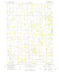
1973 Map of Millville
USGS Topo · Published 1977About this map
White Oak and the namesake settlement of Millville anchor this agricultural region of Ingham County during the early 1970s. The landscape is defined by the winding course of the West Branch Red Cedar River and numerous tributaries such as Kalamink Creek, Dietz Creek, and Doan Creek. The map reveals a dispersed rural community organized around crossroads and country churches, including the North Stockbridge Community Ch and Mt Olive Ch.
Find a feature on this map
61 named features on this map. Tap any name to fly to it.
Don’t see what you’re looking for? This feature index may not catch every label — zoom into the map to look around manually.
Map Details
Editions of this 1973 Millville Map
This is the sole edition of this map. No revisions or reprints were ever made.
Other maps of this area

1908 · Fowlerville
USGS Topo · 1:62,500

1909 · Mason
USGS Topo · 1:62,500

1910 · Fowlerville
USGS Topo · 1:62,500

1911 · Mason
USGS Topo · 1:62,500

1919 · Stockbridge
USGS Topo · 1:62,500

1919 · Rives Junction
USGS Topo · 1:62,500

1921 · Rives Junction
USGS Topo · 1:62,500

1922 · Stockbridge
USGS Topo · 1:62,500

1942 · Stockbridge
USGS Topo · 1:62,500

1958 · Grand Rapids
USGS Topo · 1:250,000