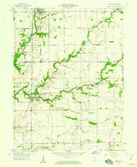
1959 Map of Milroy
USGS Topo · Published 1970About this map
Milroy and Williamstown anchor this mid-century portrait of southeastern Rush County and northern Decatur County, where the agricultural landscape is heavily punctuated by natural gas extraction. The presence of numerous Gas Wells throughout Anderson and Clinton townships highlights a period of local energy production that defined the rural economy of the 1950s. The New York Central railroad runs north-to-south, linking these agricultural hubs to the broader regional market.
Find a feature on this map
27 named features on this map. Tap any name to fly to it.
Don’t see what you’re looking for? This feature index may not catch every label — zoom into the map to look around manually.
Map Details
Editions of this 1959 Milroy Map
4 editions found
Other maps of this area

1942 · Columbus
USGS Topo · 1:125,000

1946 · New Point
USGS Topo · 1:24,000

1953 · Cincinnati
USGS Topo · 1:250,000

1957 · Cincinnati
USGS Topo · 1:250,000

1958 · Greensburg
USGS Topo · 1:24,000

1958 · Forest Hill
USGS Topo · 1:24,000

1958 · Clarksburg
USGS Topo · 1:24,000

1959 · Milroy
USGS Topo · 1:24,000

1959 · Rushville
USGS Topo · 1:24,000

1959 · New Salem
USGS Topo · 1:24,000