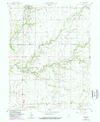
1959 Map of Milroy
USGS Topo · Published 1988About this map
Milroy and the surrounding farmland of Rush and Decatur counties are defined by a dense network of watercourses and rural industry. The Little Flatrock River winds through the northern landscape, while various branches of Sand Creek and Clifty Creek drain the southern reaches. This 1959 survey, updated with 1980s aerial data, reveals a community built around small-scale agriculture and early energy extraction, evidenced by the numerous Gas Well sites scattered throughout the terrain. Local genealogy is well-represented through family-named landmarks like Overleese Cem, Layton Cem, and Swails Cem. The area’s mid-century social character is further grounded by features such as the Springhill Ch and the Drive-in Theater located south of Williamstown. The mapping of townships like Richland and Fugit illustrates the traditional administrative boundaries that have shaped this portion of Indiana since its settlement.
Find a feature on this map
27 named features on this map. Tap any name to fly to it.
Don’t see what you’re looking for? This feature index may not catch every label — zoom into the map to look around manually.
Map Details
Editions of this 1959 Milroy Map
4 editions found
Other maps of this area

1942 · Columbus
USGS Topo · 1:125,000

1946 · New Point
USGS Topo · 1:24,000

1953 · Cincinnati
USGS Topo · 1:250,000

1957 · Cincinnati
USGS Topo · 1:250,000

1958 · Greensburg
USGS Topo · 1:24,000

1958 · Forest Hill
USGS Topo · 1:24,000

1958 · Clarksburg
USGS Topo · 1:24,000

1959 · Milroy
USGS Topo · 1:24,000

1959 · Rushville
USGS Topo · 1:24,000

1959 · New Salem
USGS Topo · 1:24,000