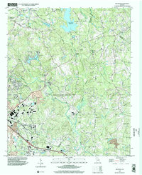
1999 Map of Milstead
USGS Topo · Published 2002About this map
The Yellow River winds through this Piedmont landscape at the turn of the millennium, connecting the industrial heritage of Milstead with the expanding commercial center of Conyers. The map captures a transition in land use, where traditional landmarks like Costley Millpond and Dials Millpond exist alongside the expansive Georgia International Horse Park, a legacy of the 1996 Olympic Games. Rural history is preserved in the naming of several country churches such as Philadelphia Ch, Double Springs Ch, and Mt Zion Ch, as well as the Hightower Indian Trail Monument near Zingara. To the north, the Black Shoals Reservoir dominates the drainage of Big Haynes Creek, providing a focal point for the region's water management and recreation. The convergence of Rockdale and Walton counties highlights the settlement patterns of towns like Almon and Oxford as they grew along historic corridors like Hightower Road.
Find a feature on this map
55 named features on this map. Tap any name to fly to it.
Don’t see what you’re looking for? This feature index may not catch every label — zoom into the map to look around manually.
Map Details
Editions of this 1999 Milstead Map
This is the sole edition of this map. No revisions or reprints were ever made.
Other maps of this area

1888 · Atlanta
USGS Topo · 1:125,000

1890 · Atlanta
USGS Topo · 1:125,000

1892 · Atlanta
USGS Topo · 1:125,000

1895 · Atlanta
USGS Topo · 1:125,000

1896 · Monroe
USGS Topo · 1:125,000

1953 · Atlanta
USGS Topo · 1:250,000

1953 · Athens
USGS Topo · 1:250,000

1956 · Snellville
USGS Topo · 1:24,000

1956 · Conyers
USGS Topo · 1:24,000

1957 · Atlanta
USGS Topo · 1:250,000