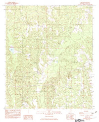
1982 Map of Milton
USGS Topo · Published 1982About this map
Milton and the surrounding Autauga County countryside appear here in the early 1980s, characterized by a complex network of waterways feeding into Mulberry Creek. The landscape is dotted with small rural communities such as Evergreen, Bonita, and Winslow, while landmarks like Dawson Mill and Walkers Lake indicate the localized industry and geography of the era. The terrain rises to significant points at Parker Mtn and Ivy Hill, providing a clear view of how development followed the natural ridges and valleys.
Find a feature on this map
22 named features on this map. Tap any name to fly to it.
Don’t see what you’re looking for? This feature index may not catch every label — zoom into the map to look around manually.
Map Details
Editions of this 1982 Milton Map
This is the sole edition of this map. No revisions or reprints were ever made.
Other maps of this area

1891 · Clanton
USGS Topo · 1:125,000

1953 · Montgomery
USGS Topo · 1:250,000

1956 · Montgomery
USGS Topo · 1:250,000

1957 · Montgomery
USGS Topo · 1:250,000

1957 · Autaugaville
USGS Topo · 1:62,500

1957 · Benton
USGS Topo · 1:62,500

1959 · Plantersville
USGS Topo · 1:62,500

1959 · Billingsley
USGS Topo · 1:62,500

1975 · Plantersville SE
USGS Topo · 1:24,000
1975 · Benton NE
USGS Topo · 1:24,000