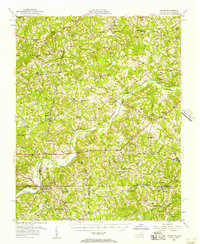
1956 Map of Milton
USGS Topo · Published 1957About this map
The Dan River meanders through the borderlands of Virginia and North Carolina, defining a landscape of tobacco-era farmsteads and rural crossroads. In the mid-1950s, this area near Milton was heavily oriented toward the river and its tributaries, such as Birch Creek and Sandy Creek. The mapping reveals a dense network of local institutions that anchored these small communities, including Wesley Chapel Ch and specialized schools like the Wilson Memorial Sch and Archibald Murphy Sch.
Find a feature on this map
91 named features on this map. Tap any name to fly to it.
Don’t see what you’re looking for? This feature index may not catch every label — zoom into the map to look around manually.
Map Details
Editions of this 1956 Milton Map
2 editions found

Other maps of this area

1921 · Chatham
USGS Topo · 1:48,000

1923 · Danville
USGS Topo · 1:48,000

1923 · Chatham
USGS Topo · 1:62,500

1925 · Danville
USGS Topo · 1:62,500

1943 · Roxboro
USGS Topo · 1:62,500

1952 · Milton
USGS Topo · 1:62,500

1953 · South Boston
USGS Topo · 1:62,500

1953 · Greensboro
USGS Topo · 1:250,000

1954 · Greensboro
USGS Topo · 1:250,000

1954 · Halifax
USGS Topo · 1:62,500