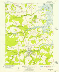
1955 Map of Milton
USGS Topo · Published 1957About this map
The town of Milton serves as the central hub of this coastal Delaware landscape, where the Broadkill River winds through tidal marshes toward the Delaware Bay. During the mid-1950s, the region's economy was anchored by small crossroads settlements and agricultural processing sites like Reynolds Mill on the Sowbridge Branch. The map reveals a complex network of coastal necks—including Slaughter Neck, Primehook Neck, and Cave Neck—defined by numerous ponds and wetlands such as Waples Pond and Ingram Pond. These features highlight the intricate relationship between the land and the shifting water levels of the bay.
Find a feature on this map
90 named features on this map. Tap any name to fly to it.
Don’t see what you’re looking for? This feature index may not catch every label — zoom into the map to look around manually.
Map Details
Editions of this 1955 Milton Map
2 editions found
Other maps of this area

1917 · Millsboro
USGS Topo · 1:62,500

1918 · Cedar Creek
USGS Topo · 1:62,500

1918 · Rehoboth
USGS Topo · 1:62,500

1918 · Cape Henlopen
USGS Topo · 1:62,500

1919 · Cedar Creek
USGS Topo · 1:62,500

1937 · Cape Henlopen
USGS Topo · 1:62,500

1938 · Cedar Creek
USGS Topo · 1:62,500

1938 · Millsboro
USGS Topo · 1:62,500

1938 · Rehoboth
USGS Topo · 1:62,500

1943 · Fairmount
USGS Topo · 1:24,000