
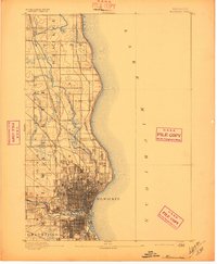
1892 Map of Milwaukee
USGS Topo · Published 1892About this map
Milwaukee at the end of the 19th century is a complex landscape defined by the convergence of major waterways and a dense rail network. The city grid occupies the southern portion of the sheet, where the Menomonee River meets the Milwaukee River before emptying into Lake Michigan. To the north, the coastline transitions into the bluffs of Whitefish Bay and the more agricultural townships of Granville and Ozaukee.
Find a feature on this map
19 named features on this map. Tap any name to fly to it.
Don’t see what you’re looking for? This feature index may not catch every label — zoom into the map to look around manually.
Map Details
Editions of this 1892 Milwaukee Map
2 editions found
Other maps of this area

1891 · Bayview
USGS Topo · 1:62,500

1891 · Muskego
USGS Topo · 1:62,500

1892 · Waukesha
USGS Topo · 1:62,500

1892 · Port Washington
USGS Topo · 1:62,500

1901 · Milwaukee
USGS Topo · 1:62,500

1901 · Waukesha
USGS Topo · 1:62,500

1901 · Bayview
USGS Topo · 1:62,500

1901 · Muskego
USGS Topo · 1:62,500

1904 · West Bend
USGS Topo · 1:62,500

1904 · Port Washington
USGS Topo · 1:62,500