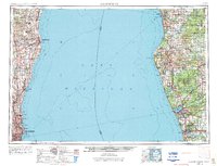
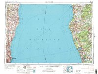
1954 Map of Milwaukee
USGS Topo · Published 1974About this map
Lake Michigan dominates the center of this mid-century survey, illustrating the maritime and industrial connection between the Wisconsin and Michigan shorelines. On the western shore, the urban expansion of Milwaukee is visible alongside established communities like Whitefish Bay and Shorewood. To the north, Sheboygan and Port Washington anchor a coastline defined by the Milwaukee River and Onion River. These Wisconsin port towns face their Michigan counterparts across the water, including the industrial hubs of Muskegon and Grand Haven.
Find a feature on this map
130 named features on this map. Tap any name to fly to it.
Don’t see what you’re looking for? This feature index may not catch every label — zoom into the map to look around manually.
Map Details
Editions of this 1954 Milwaukee Map
3 editions found

Other maps of this area

1891 · Bayview
USGS Topo · 1:62,500

1891 · Muskego
USGS Topo · 1:62,500

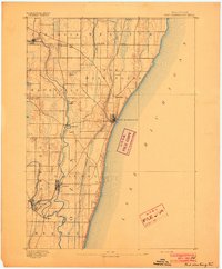
1892 · Milwaukee
USGS Topo · 1:62,500

1892 · Waukesha
USGS Topo · 1:62,500
1892 · Port Washington
USGS Topo · 1:62,500

1901 · Milwaukee
USGS Topo · 1:62,500

1901 · Waukesha
USGS Topo · 1:62,500

1901 · Bayview
USGS Topo · 1:62,500

1901 · Muskego
USGS Topo · 1:62,500

1904 · West Bend
USGS Topo · 1:62,500