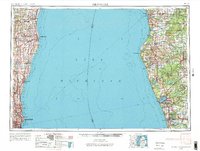
1954 Map of Milwaukee
USGS Topo · Published 1984About this map
The industrial and maritime corridors of the western and eastern shores of Lake Michigan are captured in this mid-century regional survey. On the Wisconsin coast, the dense urban expansion of Milwaukee reaches out to Wauwatosa and West Allis, while the northern shoreline is dotted with established fishing and manufacturing centers like Port Washington and Sheboygan. Ferry routes crisscross the open water, connecting these ports to Michigan timber and rail hubs such as Ludington and Muskegon. The interior of the Michigan side is dominated by the sprawling Manistee National Forest and an intricate network of inland waters including Muskegon Lake and the Pere Marquette River. This map documents a period when heavy rail lines like the Chicago and North Western and the Chesapeake and Ohio still dictated the movement of goods between these Great Lakes states.
Find a feature on this map
66 named features on this map. Tap any name to fly to it.
Don’t see what you’re looking for? This feature index may not catch every label — zoom into the map to look around manually.
Map Details
Editions of this 1954 Milwaukee Map
3 editions found


Other maps of this area

1891 · Bayview
USGS Topo · 1:62,500

1891 · Muskego
USGS Topo · 1:62,500

1892 · Milwaukee
USGS Topo · 1:62,500

1892 · Waukesha
USGS Topo · 1:62,500

1892 · Port Washington
USGS Topo · 1:62,500

1901 · Milwaukee
USGS Topo · 1:62,500

1901 · Waukesha
USGS Topo · 1:62,500

1901 · Bayview
USGS Topo · 1:62,500

1901 · Muskego
USGS Topo · 1:62,500

1904 · West Bend
USGS Topo · 1:62,500