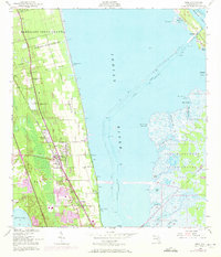
1949 Map of Mims
USGS Topo · Published 1972About this map
The Bernardo Segui Grant and Domingo Acosta Grant define the historical land division of this Florida coastal corridor, where citrus groves and early settlements developed along the Florida East Coast railway. By the mid-20th century, the landscape reflects a significant transition from traditional agricultural tracts to the arrival of the space age. The eastern shore of the Indian River is dominated by the John F Kennedy Space Center (Nasa), with its extensive network of creeks like Cow Pen Creek and Black Point Creek.
Find a feature on this map
45 named features on this map. Tap any name to fly to it.
Don’t see what you’re looking for? This feature index may not catch every label — zoom into the map to look around manually.
Map Details
Editions of this 1949 Mims Map
5 editions found
Other maps of this area

1949 · Oak Hill
USGS Topo · 1:24,000

1949 · Pardon Island
USGS Topo · 1:24,000

1949 · Orsino
USGS Topo · 1:24,000

1949 · Titusville
USGS Topo · 1:24,000

1949 · Wilson
USGS Topo · 1:24,000

1949 · Mims
USGS Topo · 1:24,000

1950 · Maytown
USGS Topo · 1:24,000

1950 · Aurantia
USGS Topo · 1:24,000

1951 · Orsino
USGS Topo · 1:24,000

1952 · Mims
USGS Topo · 1:24,000