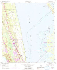
1949 Map of Mims
USGS Topo · Published 1991About this map
The Bernardo Segui Grant and Domingo Acosta Grant frame the historical land divisions along the western shore of the Indian River, preserving the legacy of Spanish land grants in Florida. This survey captures the mid-century landscape of the citrus-growing region around Mims, showing the transition from agricultural tracts to early suburban expansion. On the eastern side of the river, the massive footprint of the John F Kennedy Space Center (NASA) dominates the barrier island, intersected by the U S Government RR. This proximity between traditional settlements like La Grange and the cutting-edge aerospace facilities of the Space Age defines the area's development. Cultural landmarks such as an Indian Mound and the Arthur Dunn Airpark sit alongside smaller communities like East Mims, Wiley, and the riverside site of Paces Landing.
Find a feature on this map
36 named features on this map. Tap any name to fly to it.
Don’t see what you’re looking for? This feature index may not catch every label — zoom into the map to look around manually.
Map Details
Editions of this 1949 Mims Map
5 editions found
Other maps of this area

1949 · Oak Hill
USGS Topo · 1:24,000

1949 · Pardon Island
USGS Topo · 1:24,000

1949 · Orsino
USGS Topo · 1:24,000

1949 · Titusville
USGS Topo · 1:24,000

1949 · Wilson
USGS Topo · 1:24,000

1949 · Mims
USGS Topo · 1:24,000

1950 · Maytown
USGS Topo · 1:24,000

1950 · Aurantia
USGS Topo · 1:24,000

1951 · Orsino
USGS Topo · 1:24,000

1952 · Mims
USGS Topo · 1:24,000