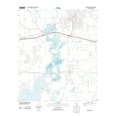
2012 Map of Minden South
USGS Topo · Published 2012About this map
Minden and the surrounding Webster Parish landscape are defined by the winding course of Bayou Dorcheat and its many tributaries, such as Cooley Br and Brushy Cr. This 2012 survey illustrates the transition from the organized grid of the city to the marshy lowlands of Tadpole Lake and the islands of Goat Island and Little Crane Island. Historically significant sites are frequent across the map, including a noted Indian Mound and a high density of family and community burial grounds like Overton Cem and Knottingham Cem. The transportation network connects the smaller settlements of Dixie Inn, Gifford, McIntyre, and Sibley, showing the ongoing spatial relationship between these communities and the wetland environment of the bayou system.
Find a feature on this map
145 named features on this map. Tap any name to fly to it.
Don’t see what you’re looking for? This feature index may not catch every label — zoom into the map to look around manually.
Map Details
Editions of this 2012 Minden South Map
This is the sole edition of this map. No revisions or reprints were ever made.
Other maps of this area

1947 · Ringgold
USGS Topo · 1:62,500

1947 · Minden
USGS Topo · 1:62,500

1948 · Jamestown
USGS Topo · 1:62,500

1949 · Jamestown
USGS Topo · 1:62,500

1949 · Minden
USGS Topo · 1:62,500

1949 · Gibsland
USGS Topo · 1:62,500

1950 · Gibsland
USGS Topo · 1:62,500

1955 · Shreveport
USGS Topo · 1:250,000

1956 · Shreveport
USGS Topo · 1:250,000

1956 · Ringgold
USGS Topo · 1:62,500