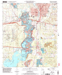
1998 Map of Minden South
USGS Topo · Published 2004About this map
Minden serves as the focal point of this North Louisiana survey, where the concentrated street grid and municipal centers like City Hall and the Courthouse give way to the sprawling industrial and natural landscape to the south. The southern reaches are dominated by the extensive Louisiana Army Ammunition Plant and the winding course of Bayou Dorcheat. This waterway eventually feeds into the northern tip of Lake Bistineau, a basin marked by islands like Goat Island and Little Crane Island.
Find a feature on this map
57 named features on this map. Tap any name to fly to it.
Don’t see what you’re looking for? This feature index may not catch every label — zoom into the map to look around manually.
Map Details
Editions of this 1998 Minden South Map
This is the sole edition of this map. No revisions or reprints were ever made.
Other maps of this area

1947 · Ringgold
USGS Topo · 1:62,500

1947 · Minden
USGS Topo · 1:62,500

1948 · Jamestown
USGS Topo · 1:62,500

1949 · Jamestown
USGS Topo · 1:62,500

1949 · Minden
USGS Topo · 1:62,500

1949 · Gibsland
USGS Topo · 1:62,500

1950 · Gibsland
USGS Topo · 1:62,500

1955 · Shreveport
USGS Topo · 1:250,000

1956 · Shreveport
USGS Topo · 1:250,000

1956 · Ringgold
USGS Topo · 1:62,500