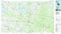
1985 Map of Mineola
USGS Topo · Published 1985About this map
Mineola and Quitman anchor this mid-1980s look at Wood County, where the landscape is defined by the massive impoundments of Lake Fork Reservoir and Lake Tawakoni. The regional economy is written in the roads and rails, with the Missouri Pacific RR and St Louis Southwestern RR cutting through towns like Grand Saline and Big Sandy. Significant infrastructure includes an extensive Oil Field and the Ambassador College Res near the Sabine River.
Find a feature on this map
165 named features on this map. Tap any name to fly to it.
Don’t see what you’re looking for? This feature index may not catch every label — zoom into the map to look around manually.
Map Details
Editions of this 1985 Mineola Map
This is the sole edition of this map. No revisions or reprints were ever made.
Other maps of this area

1920 · Kemp
USGS Topo · 1:62,500

1936 · Kilgore
USGS Topo · 1:48,000

1938 · Winona
USGS Topo · 1:48,000

1940 · Kilgore
USGS Topo · 1:62,500

1943 · Winona
USGS Topo · 1:62,500

1948 · Tyler
USGS Topo · 1:62,500

1948 · Brownsboro
USGS Topo · 1:62,500

1948 · Martins Mill
USGS Topo · 1:62,500

1949 · Tyler
USGS Topo · 1:62,500

1949 · Martins Mill
USGS Topo · 1:62,500