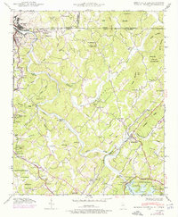
1941 Map of Mineral Bluff
USGS Topo · Published 1975About this map
The Toccoa River carves a deep path through the southern Appalachians on this 1941 survey, which captures the industrial and agricultural landscape of the Georgia-Tennessee-North Carolina borderlands. The northern portion of the map is dominated by the industrial centers of Copperhill and McCaysville, where the presence of the Isabella mine and proximity to the Louisville and Nashville railroad signify the region's mining heritage. To the south, the impact of the Tennessee Valley Authority is evident at the Blue Ridge Dam, which impounds Blue Ridge Lake. Local life is anchored by family and community landmarks like Paintertown, the Painwill Sch, and several rural burial grounds such as Galloway Cem and Allen Cem. This map records a landscape transitioning between traditional mountain farming and mid-century industrial development, with notable sites like CCC Camp 3467 marking the era's public works projects.
Find a feature on this map
82 named features on this map. Tap any name to fly to it.
Don’t see what you’re looking for? This feature index may not catch every label — zoom into the map to look around manually.
Map Details
Editions of this 1941 Mineral Bluff Map
4 editions found
Other maps of this area

1888 · Ellijay
USGS Topo · 1:125,000

1892 · Ellijay
USGS Topo · 1:125,000

1893 · Murphy
USGS Topo · 1:125,000

1898 · Ellijay
USGS Topo · 1:125,000

1911 · Ellijay
USGS Topo · 1:125,000

1914 · Murphy
USGS Topo · 1:125,000

1934 · Persimmon Creek
USGS Topo · 1:24,000

1934 · Murphy
USGS Topo · 1:48,000

1935 · Epworth
USGS Topo · 1:24,000

1935 · Mineral Bluff
USGS Topo · 1:24,000