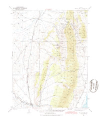
1937 Map of Mineral Hill
USGS Topo · Published 1987About this map
Mineral Hill serves as the central anchor for this 1937 survey of the High Desert, where the extraction of ore and the management of water shaped the landscape of Eureka County. The map details an era when mining activity at sites like the Bell Mine and Old Whalen Mine coincided with established ranching operations at Plummer Ranch, Bruffey Ranch, and Alpha Ranch. An abandoned rail line traces a path through Pine Valley, connecting the vanished activity at Blackburn and Alpha to the broader corridor.
Find a feature on this map
69 named features on this map. Tap any name to fly to it.
Don’t see what you’re looking for? This feature index may not catch every label — zoom into the map to look around manually.
Map Details
Editions of this 1937 Mineral Hill Map
4 editions found
Other maps of this area

1926 · Roberts Mountains
USGS Topo · 1:250,000

1929 · Roberts Mountains
USGS Topo · 1:250,000

1934 · Jiggs
USGS Topo · 1:125,000

1937 · Mineral Hill
USGS Topo · 1:48,000

1937 · Jiggs
USGS Topo · 1:125,000

1943 · Mineral Hill
USGS Topo · 1:62,500

1949 · Garden Valley
USGS Topo · 1:62,500

1949 · Roberts Creek Mtn
USGS Topo · 1:62,500

1951 · Roberts Creek Mtn
USGS Topo · 1:62,500

1951 · Garden Valley
USGS Topo · 1:62,500