
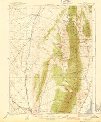
1943 Map of Mineral Hill
USGS Topo · Published 1943About this map
Mineral Hill and the surrounding mining district define this high-desert landscape in central Nevada during the late 1930s. The survey illustrates a transition in local transportation, marking the Nevada Eureka (Abandoned) line as it follows the western base of Table Mountain. This corridor once connected the small settlements of Shannon and Alpha, the latter of which is anchored by the Alpha Ranch. To the east, the topography rises sharply into the Sulphur Spring Range, a complex network of canyons like Bruffey Canyon and Slaughterhouse Canyon. This area is characterized by numerous water sources, including Hot Sprs and Warm Spring near the Bruffey Ranch. The presence of the Bell Mine and Old Whalen Mine highlights the era's ongoing reliance on the mineral wealth of the Diamond Range, while the wide expanse of Diamond Valley sits to the southeast.
Find a feature on this map
72 named features on this map. Tap any name to fly to it.
Don’t see what you’re looking for? This feature index may not catch every label — zoom into the map to look around manually.
Map Details
Editions of this 1943 Mineral Hill Map
2 editions found
Other maps of this area

1926 · Roberts Mountains
USGS Topo · 1:250,000

1929 · Roberts Mountains
USGS Topo · 1:250,000

1934 · Jiggs
USGS Topo · 1:125,000

1937 · Mineral Hill
USGS Topo · 1:48,000

1937 · Jiggs
USGS Topo · 1:125,000

1949 · Garden Valley
USGS Topo · 1:62,500

1949 · Roberts Creek Mtn
USGS Topo · 1:62,500

1951 · Roberts Creek Mtn
USGS Topo · 1:62,500

1951 · Garden Valley
USGS Topo · 1:62,500

1952 · Pine Valley
USGS Topo · 1:62,500