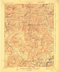
1925 Map of Mingo
USGS Topo · Published 1925About this map
Huntersville and the high ridges of the Allegheny Mountains define this 1925 survey, where the Greenbrier River bends sharply around the southern edge of the quadrangle. The map captures a landscape transitioning between remote wilderness and an active timber economy, notably documented by the Lumber R. R. cutting through the northern reaches along Leatherwood Creek. Deeply tucked into the valleys of Gauley Mountain and Cheat Mountain are numerous small rural institutions, including Marys Chapel and a dense network of mountain schools like Hannah School and Swacker School. The settlement pattern follows the narrow river bottoms and gaps, from the village of Mingo in the north to the historic crossroads at Edray. High-elevation landmarks like Big Spruce Knob and Mace Knob stand as sentinels over a rugged interior where many secondary routes connect isolated homesteads and tiny communities like Cloverlick and Warwick.
Find a feature on this map
98 named features on this map. Tap any name to fly to it.
Don’t see what you’re looking for? This feature index may not catch every label — zoom into the map to look around manually.
Map Details
Editions of this 1925 Mingo Map
4 editions found

Other maps of this area

1889 · Beverly
USGS Topo · 1:125,000

1891 · Huntersville
USGS Topo · 1:125,000

1892 · Beverly
USGS Topo · 1:125,000

1893 · Buckhannon
USGS Topo · 1:125,000

1894 · Huntersville
USGS Topo · 1:125,000

1896 · Buckhannon
USGS Topo · 1:125,000

1897 · Buckhannon
USGS Topo · 1:125,000

1901 · Monterey
USGS Topo · 1:125,000

1913 · Hacker Valley
USGS Topo · 1:48,000

1913 · Pickens
USGS Topo · 1:48,000